
The 7-Day West Highland Way Itinerary: The Health-Smart Version
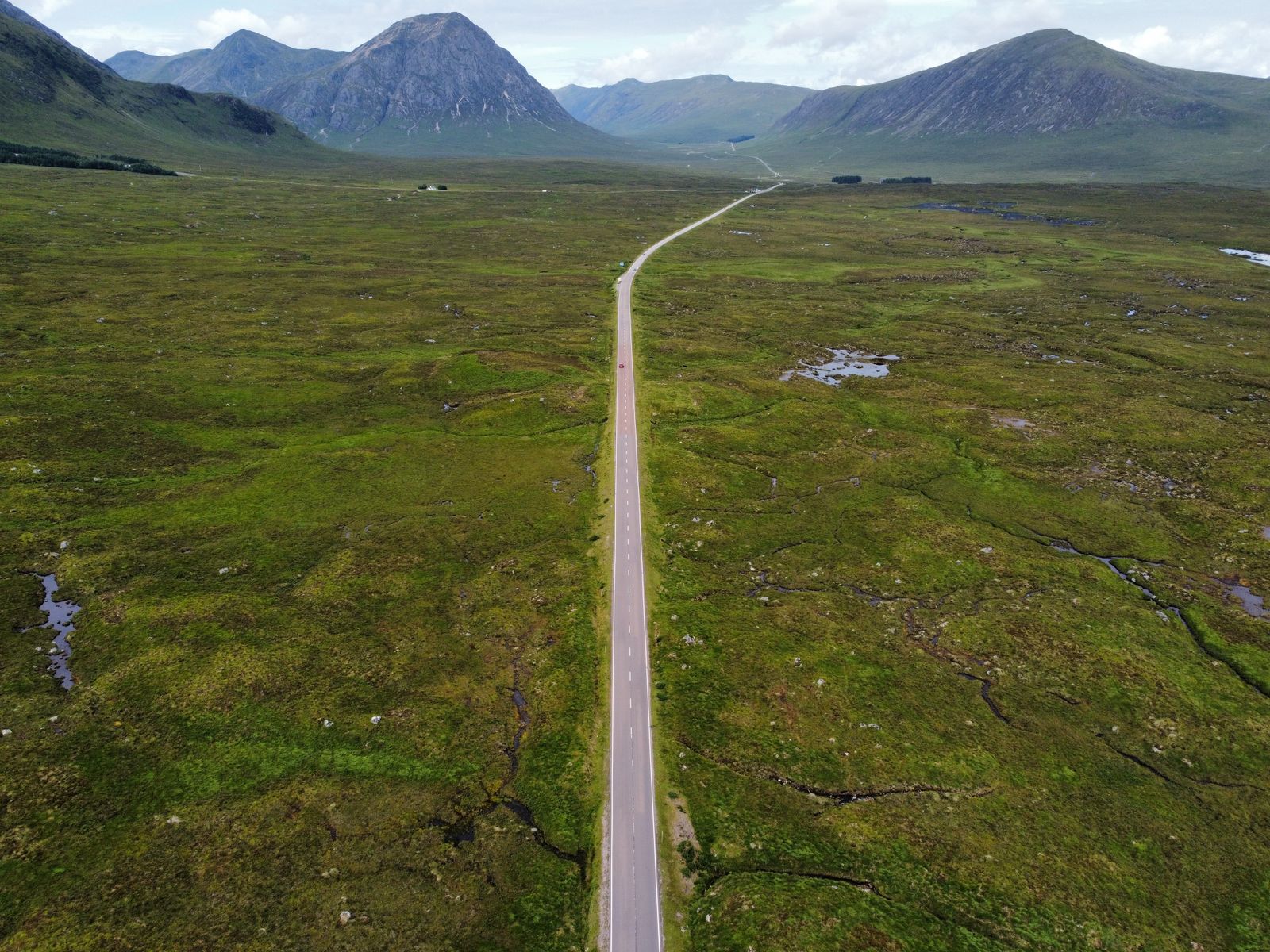
The West Highland Way runs about 96 miles (154 km) from Milngavie to Fort William, most commonly walked over 7 stages through Loch Lomond, Rannoch Moor, and Glen Coe. This is not an altitude or malaria trip; Scotland is a low-risk destination by CDC criteria, and the trail's highest point, the Devil's Staircase, tops out around 550 meters, well below the altitude where mountain sickness becomes a concern. The real risk is logistical. Consecutive 9-to-19-mile days eating from bunkhouse kitchens and trailside cafes, refilling water across remote moorland, put real distance between a walker and the nearest pharmacy if a gut bug or overuse injury hits mid-route. Most travelers should carry azithromycin for traveler's diarrhea, prescription-strength ibuprofen for cumulative joint strain, and dicyclomine for cramping before they leave home.
Ninety-six miles from a Glasgow suburb to the foot of Ben Nevis, walked over back-to-back days through Loch Lomond, Rannoch Moor, and Glen Coe. The West Highland Way is not a technical trek and it is not an altitude trip. It is a long-distance endurance walk through some of Europe's most remote countryside, and the health factor that actually shapes the trip is logistics, not elevation. When you are eating from bunkhouse kitchens for a week straight and refilling your water bottle from open moorland streams, a gut bug or a blown-out knee on day five is a very different problem than the same issue at home, since the nearest pharmacy can be a full day's walk away. This itinerary builds the trail's real risk profile into the plan from day one, rather than treating health as an afterthought bolted onto a generic hiking guide.
Who this itinerary is for
This route suits first-time long-distance walkers who have some hill-walking or multi-day backpacking experience and want a well-waymarked, service-supported trail rather than a true wilderness expedition. Baggage transfer services and bunkhouse, hostel, or B&B accommodation are available at every stage, so most walkers never carry more than a light day pack, and mobile signal is workable in the towns even if patchy on the moor. As covered in our broader United Kingdom health guide, Scotland requires no visa for most travelers and no special entry vaccinations, and the logistics of getting to Milngavie by train from Glasgow are simple, which makes this one of the more approachable long-distance treks in Europe for someone building toward bigger routes.
Returning trekkers and those coming from higher-altitude routes like the Alps, the Andes, or the Himalaya should recalibrate expectations rather than assume this will feel easy by comparison. There is no acclimatization schedule to manage here, and no oxygen or altitude medication to think about. Instead, the challenge is cumulative and logistical: six to nine days of 9-to-19-mile stages on tired legs, with weather that can shift from sun to horizontal rain within the same hour, and long stretches, particularly across Rannoch Moor, where the nearest village, shop, or pharmacy is genuinely hours away on foot.
The route
The Way runs south to north, starting in Milngavie just north of Glasgow and finishing in Fort William beneath Ben Nevis, Britain's highest peak. The first two days are the gentlest, tracking farmland, forest, and quiet lochs before climbing over Conic Hill for the first proper views down Loch Lomond and its scattering of wooded islands. Days three and four hug the loch's eastern shore on narrow, rooty path through the Inversnaid and Inverarnan area, some of the slowest ground on the entire route, before the terrain finally opens onto the wide moorland approach toward Tyndrum and Bridge of Orchy.
The middle of the trip is where the trail earns its reputation. A long crossing of Rannoch Moor, one of the most remote and undeveloped landscapes in Britain, gives way to the Devil's Staircase, a zigzag climb into Glen Coe that marks the high point of the entire route at roughly 550 meters. The final two days descend to the loch-side village of Kinlochleven and then climb once more through the old military road at Lairigmor before dropping through Nevis Forest into Fort William, with Ben Nevis visible for much of the last stretch. Total elevation gain and loss across the full route runs to roughly 3,155 meters, more cumulative climbing than most walkers expect from a trail with no single mountain summit on it.
Day-by-day plan
Day 1: Milngavie to Drymen (about 12 miles / 19 km)
The easiest stage on the route, following forest track through Mugdock Wood, past Craigallian Loch, and across quiet farmland to the small town of Drymen. There's no real elevation to speak of and services are frequent, which makes this the day to break in boots, dial in your pack fit, and test your rain gear rather than push pace. Most trip-ending blisters trace back to a boot problem nobody addressed on day one.
Day 2: Drymen to Rowardennan (about 14 miles / 23 km)
The climb over Conic Hill crosses the Highland Boundary Fault, the geological line separating Scotland's Lowlands from the Highlands, and delivers the first wide views over Loch Lomond and its islands before the path drops to the lochside at Balmaha and continues north to Rowardennan. Sun and wind exposure on the open hill can catch people off guard even on a mild day, so hydrate and apply sun protection before the climb starts, not partway up it.
Day 3: Rowardennan to Inverarnan (about 14 miles / 22 km)
This is the slowest, most technical section of the Way, a narrow lochside path through roots, boulders, and short scrambles along Loch Lomond's northern shore, with almost no road access for long stretches. Many walkers who plan pace based on earlier, easier days get caught out here. Ankle-turn risk is higher on this stage than anywhere else on the route, and it's also wooded and bracken-heavy in places, which is exactly the terrain where a tick-bite check at the end of the day matters most.
Day 4: Inverarnan to Tyndrum (about 12 miles / 19 km)
The terrain opens into easier moorland grade as the route passes through Crianlarich and follows the old drove road once used to move cattle to Lowland markets. Water refill points shift from bunkhouse taps to open streams and burns today. Research on Scottish hill water suggests the overall risk of picking up Giardia or Cryptosporidium from clean, remote mountain streams is low, but water drawn nearer sheep or cattle grazing land should still be treated, since livestock contamination has caused documented waterborne outbreaks elsewhere in Scotland.
Day 5: Tyndrum to Kingshouse via Bridge of Orchy (about 19 miles / 31 km)
The longest day on the trail, crossing Rannoch Moor's roughly 50 square miles of open bog, heather, and lochans with minimal services between the small settlements of Bridge of Orchy and the Kingshouse Hotel. This is the farthest point on the route from a pharmacy or clinic, and weather on the open moor can turn quickly with little shelter. Carry your travel-medicine kit and any prescriptions on your body in your day pack today, not in a bag transferred ahead by courier van.
Want the health prep for Scotland?
Get a 60-second pre-trip check: the vaccines, prescriptions, and altitude/seasonality notes that change the plan — built for your exact dates.
Day 6: Kingshouse to Kinlochleven (about 9 miles / 14 km)
Short in distance but the trail's defining climb: the Devil's Staircase, a switchback ascent to roughly 550 meters, the highest point on the entire West Highland Way, opening onto sweeping views of Glencoe and the Mamores before a long descent into the village of Kinlochleven. Below the roughly 2,500-meter altitude where mountain sickness starts to become a realistic concern, this is not an altitude-medication day. The real hazard here is fast-changing Highland weather at exposed elevation, including sudden wind, rain, or reduced visibility even in summer.
Day 7: Kinlochleven to Fort William (about 15 miles / 24 km)
The final push, climbing through the Lairigmor pass on an old military road and through Nevis Forest with Ben Nevis in near-constant view before the descent into Fort William. Cumulative strain from six prior days of long mileage tends to surface here as knee, shin, or foot pain rather than anything acute, which is exactly the kind of overuse injury that responds well to anti-inflammatory medication carried from home rather than a same-day pharmacy run in an unfamiliar town.
Health prep for this trip
The realistic health risk on the West Highland Way is traveler's diarrhea, not altitude or an exotic infection. A week of communal bunkhouse kitchens, trailside cafes, and packed lunches, combined with days where turning back isn't simple once you're committed to a stage, is the setup most walkers should plan around. Most travelers should fill a prescription for azithromycin before departure, since it treats bacterial TD in a short course without the resistance concerns tied to some older options, alongside dicyclomine for the cramping and gut spasms that often accompany it.
Cumulative joint and soft-tissue strain from consecutive long days is the second real issue on this route. Prescription-strength ibuprofen covers knee, shin, and foot pain that tends to build from day four onward, particularly across the technical Rowardennan-to-Inverarnan stage and the long Kinlochleven-to-Fort William finish. CDC also flags tick-borne illness as a specific UK travel consideration, noting that the Highland glens carry the country's highest reported Lyme disease incidence, so covering exposed skin through the wooded, bracken-heavy sections around Loch Lomond and checking your body each evening are reasonable precautions. Routine vaccines, including MMR and Tdap, should also be current before any international trip, per general CDC travel guidance. The West Highland Way travel medicine bundle covers all three prescriptions, azithromycin, ibuprofen, and dicyclomine, in a single online visit before you fly.
What to pack
- Broken-in waterproof boots and at least one backup pair of hiking socks per two days of walking
- Trekking poles, especially useful on the technical Rowardennan-to-Inverarnan lochside stage
- A lightweight water filter or purification tablets for backcountry stream refills
- Layered waterproofs; Highland weather can change faster than a forecast updates
- Blister prevention supplies (tape, moleskin) packed in your day bag, not in luggage transferred ahead
- Insect repellent and a head net if walking between May and September, when midges are active
- A basic first-aid kit alongside your filled travel-medicine prescriptions
Best time to go and what to avoid
Late April through May and September tend to offer the mildest weather and the lightest midge activity on the trail. Midges, the small biting insects that become a genuine nuisance across the Highlands, are generally present from mid-May through mid-September, with the biting females typically arriving in early June and peaking in the warmer, stiller evenings of June through August. May is also typically the driest and sunniest month on the route and the single most popular month to walk it, while September brings cooler temperatures and autumn color with midge activity largely tapering off by the second half of the month.
Cost expectations
A self-guided 7-day West Highland Way trip typically runs from moderate to mid-range depending on accommodation choice, with bunkhouses and hostels at the lower end and B&Bs or small hotels considerably higher, especially during the busy May and September windows when advance booking matters. Most walkers also book a baggage transfer service between stages, which adds a modest daily fee but removes the need to carry a full pack over the technical lochside terrain. Budget separately for a pre-trip online visit to get travel-medicine prescriptions filled before departure, since sourcing them once you're on the trail is not realistic given how remote several stages are.
Day-by-day plan
| Day | What you're doing | Health note |
|---|---|---|
| 1 | Milngavie to Drymen Gentle warm-up through Mugdock Wood and past Craigallian Loch, about 12 miles (19 km) on good forest track and farmland paths. | Break in boots and test your pack fit today. This is the easiest day on the route, use it to catch blisters before they start. |
| 2 | Drymen to Rowardennan About 14 miles (23 km), climbing over Conic Hill across the Highland Boundary Fault for the first open views down Loch Lomond, then dropping to the lochside. | Exposed hill sections mean real sun and wind exposure even on a mild day. Hydrate before the climb, not during it. |
| 3 | Rowardennan to Inverarnan Roughly 14 miles (22 km) of narrow, rooty, rock-strewn path hugging the loch shore, the slowest and most technical miles on the entire Way. | Ankle-turn risk is highest here. Trekking poles and full-coverage boots matter more today than on any other stage. |
| 4 | Inverarnan to Tyndrum About 12 miles (19 km) as the route opens onto easier moorland grade, passing the ruined Crianlarich woods and the old drove road. | Refill points shift to open streams today. Treat water drawn near grazing land, even though Scottish hill water carries a low overall risk. |
| 5 | Tyndrum to Kingshouse via Bridge of Orchy The longest day, about 19 miles (31 km), crossing the vast, treeless expanse of Rannoch Moor with almost no services between villages. | This is the farthest you'll be from a pharmacy on the entire trip. Carry your travel-medicine kit on your body, not just in a transferred bag. |
| 6 | Kingshouse to Kinlochleven About 9 miles (14 km), short on distance but the trail's hardest climb: the Devil's Staircase, a zigzag ascent to roughly 550 meters, the highest point on the Way. | Below 2,500 meters, altitude illness is not a realistic concern here. The real hazard is fast-changing Highland weather at exposed elevation. |
| 7 | Kinlochleven to Fort William The final stretch, about 15 miles (24 km), climbing through Lairigmor and Nevis Forest with Ben Nevis in view before descending into Fort William. | Cumulative strain peaks on the last long day. This is when overuse injuries in the knees, shins, and feet tend to surface. |
Frequently Asked Questions
Most travelers should simply confirm they are current on routine vaccines, including MMR and Tdap, which CDC recommends for all international travelers regardless of destination. The UK is not a yellow fever or malaria destination, so no trip-specific vaccination is typically required for this route. Speak with a provider to confirm what applies to your personal health history.
Tap water in towns and bunkhouses along the route is treated and safe. Backcountry water drawn from Highland streams and lochans carries a low overall risk of Giardia or Cryptosporidium in Scotland, though contamination from livestock grazing has caused documented outbreaks in the region historically. Most walkers should treat or filter water drawn near sheep or cattle pasture as a reasonable precaution.
It is traveler's diarrhea, not altitude or infectious disease. Eight to nine days of eating from shared bunkhouse kitchens, trailside cafes, and packed lunches, combined with long days that leave little margin if a gut bug hits, is the realistic risk profile most walkers should plan around.
No. The trail's highest point, the Devil's Staircase near Kingshouse, sits at roughly 550 meters, well under the approximately 2,500-meter threshold where acute mountain sickness typically becomes a concern. This is a low-altitude trek by any standard measure.
Yes, and CDC specifically flags tick-borne illness as a UK travel consideration, noting the Highland region carries the country's highest reported Lyme disease incidence. Wearing long sleeves and pants through wooded or bracken-heavy sections, using an EPA-registered repellent, and checking your skin each evening are reasonable precautions.
Most walkers with regular hiking experience and a baseline of consecutive long-distance walking can complete the route in 6 to 9 days. The back-to-back nature of the days, not any single stage, is what wears people down. Building up training miles in the weeks before departure matters more than raw speed.
The Tyndrum-to-Kingshouse stage and the Rannoch Moor crossing put real distance between you and the nearest pharmacy or clinic. Most travelers should carry a filled prescription for traveler's diarrhea and pain management before departure rather than plan to seek care mid-route, since same-day access to a pharmacy is not guaranteed on these stages.
Mark Karam, PA-C is a board-certified Physician Associate with emergency and urgent care experience and co-founder of Wandr Health.