
The 8-Day Tibet Itinerary: Lhasa to Everest North Base Camp, The Health-Smart Version

Tibet is the rare trip that begins at altitude instead of building toward it. Most travelers fly straight into Lhasa at roughly 3,700 m (12,100 ft), and CDC notes that rapid ascent by air to above 3,400 m places travelers in a high-risk category for acute mountain sickness, with rates of altitude illness approaching 50%. This 8-day itinerary front-loads three nights in Lhasa before any driving, then splits the climb toward Everest North Base Camp across two nights instead of one. The single change I would make to a standard Tibet tour is that extra night near Shegar at about 4,350 m. Most travelers should also start acetazolamide the day before flying up, since CDC notes it is not reliably available in China.
Almost every itinerary problem in Tibet traces back to one fact: the trip starts at altitude rather than climbing toward it. You board a plane near sea level and step off a few hours later at roughly 3,700 m, which CDC lists alongside Cusco and La Paz as a destination where rapid air ascent puts travelers into the high-risk category for acute mountain sickness. Then the classic route keeps climbing for six more days. Nothing about that is a reason to skip Tibet. It is a reason to build the schedule around acclimatization from day one, which is what the eight days below actually do.
Who this itinerary is for
This is a first-timer's Tibet route, and it assumes you are arriving from low elevation with no recent time spent high. It is a vehicle-based trip rather than a trek. The physical demands are modest: stairs at the Potala, short walks at monasteries, standing outside at 5,000 m in cold wind. What is demanding is the altitude itself, and that affects fit twenty-somethings and comfortable sixty-somethings roughly equally. CDC is clear that training and physical fitness do not affect altitude illness risk, and that a traveler's sex plays minimal role if any.
If you have been to 4,000 m or higher recently and did well on a similar ascent profile, you have the single most useful predictor available, though CDC cautions it is not infallible. If you have coronary artery disease, chronic lung disease, obstructive sleep apnea, or sickle cell trait, this route deserves a conversation with a physician familiar with high-altitude medicine before you book. If you are pregnant, CDC's guidance that sleeping above 3,050 m is best avoided rules out essentially this entire itinerary, including Lhasa.
The route
Everything runs southwest from Lhasa along the Friendship Highway, the paved road that continues on to the Nepal border. The shape is simple even if the numbers are not.
You start in Lhasa at 3,656 m and stay put for three nights. This is not padding. It is the acclimatization block that makes the rest of the trip survivable, and cutting it is the most common mistake in six-day versions of this tour.
From Lhasa the road climbs over Kamba La at 4,794 m, drops past the long turquoise arm of Yamdrok Lake, and delivers you to Gyantse at 4,050 m. The next leg is short and slightly downhill to Shigatse at 3,845 m, Tibet's second city and home to Tashilhunpo Monastery.
Then comes the part that separates a health-smart itinerary from a standard one. Shigatse to Rongbuk is commonly driven in a single day, crossing Gyatso La at 5,248 m and ending at roughly 5,000 m. That is a sleeping-altitude gain of about 1,150 m in one night. The Wilderness Medical Society guidance CDC cites recommends moving sleeping altitude by no more than 500 m per night once above 3,000 m, with an extra acclimatization night for every 1,000 m gained. A single-day version violates both halves of that. This itinerary splits it, sleeping near Shegar at about 4,350 m on night six and reaching Rongbuk on night seven.
Day eight runs the whole thing back down the plateau, which is the most reliable altitude treatment there is.

Day-by-day plan
Day 1: Fly into Lhasa (3,656 m) and do almost nothing
Land at Gonggar, transfer roughly 60 km into the city, check in, and stop. No temple, no market, no walk to stretch your legs. This is the single most disregarded day of any Tibet trip and the one that pays the most.
CDC's acclimatization checklist for this window is specific: mild exercise only for the first 48 hours, no alcohol for the first 48 hours, and if you are a regular caffeine user, keep drinking it so a withdrawal headache does not get mistaken for an altitude headache. Drink water steadily. Eat even if your appetite has vanished, because loss of appetite is itself an early AMS symptom rather than just travel fatigue.
Day 2: Jokhang Temple and the Barkhor kora
Flat walking in the old city, pilgrims circling the Barkhor clockwise, butter lamps and juniper smoke inside Jokhang. Keep the pace slow enough to hold a conversation.
How you slept matters more than how you feel at breakfast. CDC notes AMS symptoms typically begin 2 to 12 hours after arrival at altitude, often during or after the first night, and that headache is the cardinal symptom, usually with at least one of anorexia, dizziness, fatigue, nausea, or occasionally vomiting. If that describes your night, today stays flat and tomorrow's plan gets reconsidered.
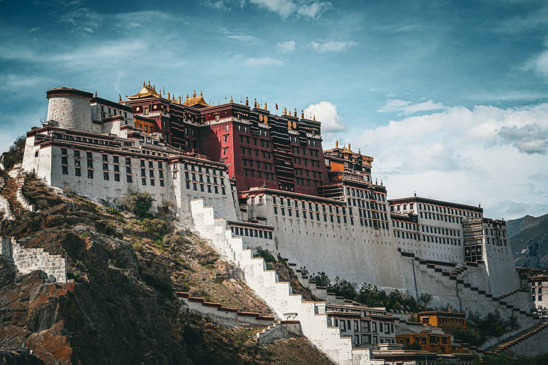
Day 3: Potala Palace and Sera Monastery
The Potala is the first real exertion of the trip, several hundred steps climbing the face of Marpo Ri. Take it in stages. In the afternoon, the courtyard debates at Sera are a good low-effort counterweight.
Use the stairs as a self-test. Breathlessness climbing at 3,656 m is normal. Breathlessness far out of proportion to the effort, especially with a cough or chest congestion, is worth flagging to your guide before you leave the city, since Lhasa has the best medical access you will see all week.
Day 4: Lhasa to Gyantse (4,050 m) via Kamba La and Yamdrok Lake
A long driving day, roughly 260 km, cresting Kamba La at 4,794 m with Yamdrok Lake stretched out below in a colour that photographs badly and looks unreal in person.
This is a textbook climb-high, sleep-low day. You spend twenty minutes at nearly 4,800 m and then sleep almost 750 m lower. Day trips to high altitude with an evening return to lower elevation are, as CDC puts it, much less stressful on the body, because hypoxemia is greatest during sleep. Enjoy the pass, then get back in the vehicle.
Want the health prep for China?
Get a 60-second pre-trip check: the vaccines, prescriptions, and altitude/seasonality notes that change the plan — built for your exact dates.
Day 5: Gyantse to Shigatse (3,845 m)
Morning at Pelkor Chode Monastery and the Gyantse Kumbum, a stacked chapel-by-chapel tower you climb slowly by design. Then a short 90 km run to Shigatse and Tashilhunpo Monastery.
Tonight your sleeping altitude drops about 200 m from Gyantse. That is deliberate. Treat this as the last comfortable evening before the climb west: eat a real dinner, hydrate, and repack so your medication kit is reachable rather than buried.
Day 6: Shigatse to Shegar (about 4,350 m) over Gyatso La
The road climbs to Gyatso La at 5,248 m, the highest point the highway crosses and the gateway to the Everest reserve, then descends toward Shegar and the Tingri plain.
Stopping here instead of pushing to Rongbuk is the health decision of the whole itinerary. It converts one 1,150 m sleeping-altitude jump into two gains of roughly 500 m and 650 m, which lands far closer to the 500 m per night ceiling CDC cites from Wilderness Medical Society guidance. Nights at Shegar are cold and the accommodation is basic. It is still the right call.

Day 7: Shegar to Rongbuk and Everest North Base Camp (about 5,000 m)
The road switchbacks over Gawu La at roughly 5,200 m, where on a clear day you can pick out several 8,000 m peaks in one sweep, then drops into the Rongbuk valley with the north face filling the horizon. Rongbuk Monastery sits just below base camp and is generally described as the highest monastery in the world.
You are now sleeping near 5,000 m, close to the ceiling of about 5,200 m that CDC describes the body as able to adjust to. Expect broken sleep. CDC notes that above roughly 2,700 m some degree of periodic breathing becomes nearly universal, and that acetazolamide is effective for it. Do not use alcohol or opiates to force sleep here, which CDC explicitly warns against as respiratory depressants at altitude.
Day 8: Descend toward Shigatse or Lhasa
Get up for sunrise on the north face, then start down. The drive is long and the plateau scenery is genuinely better in this direction.
If you picked up a headache at Rongbuk, this is when it resolves. CDC notes travelers with AMS improve rapidly with descent of 300 m or more, and today you will lose well over a thousand.
Health prep for this trip
Vaccines. CDC recommends travelers to China be up to date on routine vaccines and considers hepatitis A and typhoid, with typhoid particularly worth discussing for rural itineraries, which the Friendship Highway certainly is. Japanese encephalitis is not indicated for a Tibet-only route, since CDC notes JE occurs in all regions of China except Qinghai, Xinjiang, and Xizang. Rabies is worth raising if your itinerary extends into lower-elevation China, where CDC flags dog bites as a real risk for travelers. Start this conversation about eight weeks out at our vaccines page.
Altitude prescriptions. This is the piece most travelers underestimate, and there is a logistical trap in it. CDC states plainly that visitors whose itineraries do not permit gradual acclimatization should carry their own supply of acetazolamide because it is not reliably available in China. You cannot plan to sort this out in Lhasa. Most travelers should discuss starting acetazolamide the day before flying up, at CDC's described prophylactic dose of 125 mg every 12 hours, continuing while ascent continues. The Tibet altitude travel pack covers this alongside the supporting medications below.
Symptom management. CDC describes self-treatment of AMS without cerebral or pulmonary edema as a non-opiate analgesic plus an antiemetic, specifically naming ibuprofen 600 mg every 8 hours and ondansetron 4 mg orally disintegrating tablets. Ibuprofen has separate evidence as prevention: CDC notes 600 mg every 8 hours helps prevent AMS, though not as effectively as acetazolamide. Ondansetron matters more here than on most trips, because vomiting at 5,000 m in a Rongbuk guesthouse is how a manageable situation becomes a dehydrated one.
Stomach cover. CDC puts travelers' diarrhea attack rates in China at 10% to 20% depending on itinerary and food choices, with risk moderate outside luxury accommodation. Tap water is not safe to drink in mainland China outside Hong Kong. Most travelers on this route should carry a prescription antibiotic such as azithromycin, typically 500 mg once daily for three days, so an illness two days from the nearest hospital does not become an evacuation. Broader context on vaccines, water, and regional risk sits on the China destination guide.
The three rules. CDC reduces altitude safety to three: know that early symptoms resemble a hangover and be willing to admit you have them; never ascend to sleep higher while symptomatic, however minor it seems; and descend if symptoms worsen despite rest or treatment. Agree these with your guide on day one, before anyone has a reason to argue.
What to pack
- Your full medication kit in carry-on, not checked luggage, with prescriptions labelled
- A pulse oximeter, which CDC notes is available for under $30 and useful for tracking acclimatization trend
- Genuine cold-weather layers for Rongbuk, including a warm hat and gloves, even in summer
- High-SPF sunscreen, SPF lip balm, and category 4 sunglasses for the ultraviolet exposure CDC flags at high elevation
- A refillable bottle plus a purification method, given the tap water advice
- Oral rehydration salts, which weigh nothing and matter most exactly where pharmacies do not exist
- Copies of your prescriptions, which China expects travelers to carry for medications brought in
Best time to go and what to avoid
The question is really about cloud. Everest's north face is visible far more reliably in the shoulder seasons than in summer, and Rongbuk is genuinely punishing in deep winter.
Altitude risk itself does not change much by season, since it tracks your ascent profile rather than the calendar. What changes is comfort, road reliability, and whether you see the mountain you came for.
Cost expectations
Tibet is more expensive per day than most of China because independent travel is not permitted. Foreign visitors need a Tibet Travel Permit arranged through a licensed agency, plus a guide and, beyond Lhasa, a driver and vehicle. Budget roughly $1,200 to $2,200 per person for an eight-day guided version of this route excluding international flights, with the Everest leg and permits accounting for a meaningful share. Splitting the drive with an extra night near Shegar typically adds a modest amount to that figure, which is the cheapest insurance on the entire trip.
Day-by-day plan
| Day | What you're doing | Health note |
|---|---|---|
| 1 | Fly into Lhasa (3,656 m) and do almost nothing Arrive at Gonggar Airport, transfer to Lhasa, unpack, and stay horizontal. No sightseeing. | You have just gained roughly 3,600 m in a few hours. CDC advises only mild exercise and no alcohol for the first 48 hours at altitude. |
| 2 | Lhasa on foot: Jokhang Temple and the Barkhor kora Flat, slow walking in the old city. Jokhang Temple, the Barkhor circuit, tea houses. | Symptoms usually appear 2 to 12 hours after arrival, often overnight. Judge how you slept before committing to anything harder. |
| 3 | Potala Palace and Sera Monastery, still at 3,656 m The Potala's stair climb, then the afternoon monk debates at Sera. | The Potala involves several hundred steps. If stairs leave you far more breathless than expected, that is information worth acting on. |
| 4 | Drive to Gyantse (4,050 m) over Kamba La and Yamdrok Lake Roughly 260 km southwest, cresting Kamba La at 4,794 m with Yamdrok Lake below. | A classic climb-high, sleep-low day. You touch 4,794 m at the pass but sleep almost 750 m lower in Gyantse. |
| 5 | Gyantse to Shigatse (3,845 m) Pelkor Chode Monastery and the Gyantse Kumbum, then a short drive to Tashilhunpo in Shigatse. | Sleeping altitude drops about 200 m tonight. Use the easy day to eat and hydrate properly before the climb west. |
| 6 | Shigatse to Shegar (about 4,350 m) over Gyatso La The Friendship Highway crosses Gyatso La at 5,248 m, the trip's highest road point, before dropping to Shegar. | This extra night is the health decision of the whole trip. It halves what is otherwise a single 1,150 m jump in sleeping altitude. |
| 7 | Shegar to Rongbuk and Everest North Base Camp (about 5,000 m) Over Gawu La at roughly 5,200 m, then down to Rongbuk Monastery and the north face viewpoint. | Your highest sleeping altitude, near the ceiling of about 5,200 m that CDC describes the body as able to adjust to. |
| 8 | Descend to Shigatse or Lhasa Sunrise on the north face, then the long drive back down the plateau. | Descent is the treatment. Most mild symptoms picked up at Rongbuk resolve within hours of losing 1,000 m. |
Frequently Asked Questions
Most travelers should discuss it seriously. CDC notes that destinations requiring rapid ascent by airplane to above 3,400 m place travelers in a high-risk category for acute mountain sickness, with rates of altitude illness approaching 50%, and advises a low threshold for chemoprophylaxis in those situations. Flying into Lhasa at roughly 3,700 m is exactly that scenario, and unlike Cusco or La Paz there is no lower valley nearby to sleep in first. Speak with a licensed provider about whether acetazolamide is appropriate for you.
CDC describes an effective prophylactic dose of 125 mg every 12 hours, beginning the day before ascent and continuing the first two days at altitude, and longer if ascent continues. Because this itinerary keeps climbing through day 7, most travelers would continue through the Everest leg rather than stopping after 48 hours in Lhasa. Your prescriber should confirm dosing and duration for your specific health history.
Usually yes. CDC states that acetazolamide is a sulfonamide derivative but a non-antimicrobial one, and that cross-sensitivity between antimicrobial sulfonamides and acetazolamide has not been reported, so people allergic to sulfa antibiotics can generally take it. CDC does advise caution for anyone with a history of anaphylaxis to any medication or multiple drug allergies. Raise your allergy history with your provider directly.
Eight days is workable and is roughly the shortest sensible version. Many operators sell the same route in 6 or 7 days by cutting Lhasa to two nights or by driving Shigatse to Rongbuk in a single day. Both cuts remove acclimatization time at the two points where this itinerary deliberately spends it. If you can add a day, add it in Lhasa. If you can add two, put the second near Shegar.
No. WHO declared China malaria-free in 2021, and the Tibetan plateau sits far too high and cold to support transmission in any case. CDC also notes that Japanese encephalitis occurs in all regions of China except Qinghai, Xinjiang, and Xizang (Tibet), so a Tibet-only itinerary does not carry that indication either. Altitude, not mosquito-borne disease, is the risk that defines this trip.
Meaningful but manageable. CDC describes travelers' diarrhea risk in China as low in luxury accommodations and moderate elsewhere, and reports attack rates in the range of 10% to 20% depending on itinerary and food choices. Guesthouses along the Friendship Highway sit at the moderate end. Tap water is not safe to drink anywhere in mainland China outside Hong Kong. Many travelers carry a prescription antibiotic such as azithromycin so a bad night at 4,350 m does not end the trip.
Mild acute mountain sickness at 5,000 m is common and usually self-limited. CDC notes that AMS improves rapidly with a descent of 300 m or more, and that travelers without high-altitude cerebral edema or pulmonary edema can self-treat at their current altitude with a non-opiate analgesic such as ibuprofen 600 mg every 8 hours and an antiemetic such as ondansetron 4 mg orally disintegrating tablets. The rule that matters: never ascend to sleep higher while you have symptoms, and descend if symptoms worsen despite treatment.
April to May and September to October give the clearest odds of an unobstructed north face. Summer brings monsoon-driven cloud that frequently hides the mountain even in otherwise pleasant weather, and winter brings extreme cold at Rongbuk with reduced guesthouse availability. Late September and early October combine settled skies with roads that are still comfortably open.
It is a reasonable, low-cost addition. CDC notes that with pulse oximeters available for under $30, travelers may want to carry one to gauge acclimatization progress. Treat it as a trend tool rather than a verdict. CDC is explicit that AMS is diagnosed on symptoms and recent ascent history, and that oxygen saturation in AMS is often within the normal range for the altitude.
It requires a real conversation first. CDC advises that travelers with coronary artery disease, any form of chronic pulmonary disease or preexisting hypoxemia, obstructive sleep apnea, or sickle cell trait consult a physician familiar with high-altitude medicine before undertaking this kind of travel, even when the condition is well controlled. CDC also suggests it is prudent for pregnant travelers to avoid sleeping above 3,050 m, which rules out this route. Medical care west of Shigatse is limited and evacuation is slow.
Alec Freling, MD is a board-certified emergency medicine physician and co-founder of Wandr Health with ER experience treating returning travelers.