The 7-Day Bolivia Salt Flats Itinerary: The Health-Smart Version
This 7-day Bolivia route lands you in La Paz (3,640 m), holds you there for two acclimatization nights, then crosses Salar de Uyuni (3,656 m) and the Eduardo Avaroa lagoons, where altitude tops out near 4,900 m at the Sol de Mañana geysers. The whole trip sits above 3,000 m. Per CDC, 40 to 50 percent of unacclimatized travelers develop acute mountain sickness within 12 hours at sustained altitudes over 3,000 m, so the plan is paced to climb gradually rather than fast. As a PA-C, my one rule for this trip: build the acclimatization days in first, then talk to a provider about acetazolamide before you go.
The Bolivia salt flats are one of the few trips where the scenery and the medicine are the same conversation. You are not just chasing the mirror-flat horizon of Salar de Uyuni; you are spending a full week above 3,000 m, climbing toward geysers near 4,900 m, and asking a lot of your lungs the entire time. I am a PA-C, and the version of this trip that goes wrong almost always starts the same way: a traveler flies straight to the altiplano and tries to sightsee on day one. This 7-day plan is built to prevent that. Acclimatize first, climb gradually, and the salt flats become the trip you actually came for.
Who this itinerary is for
This route works for reasonably fit travelers who can handle long days in a 4x4 and basic accommodation on the remote southern circuit. You do not need to be an athlete. You do need to respect altitude, because fitness does not protect you from it. Plenty of marathon runners get acute mountain sickness; the body's response to thin air is mostly about time, not conditioning.
It is a strong fit for first-timers to high altitude as long as they take the acclimatization days seriously, and for returning altiplano travelers who already know how their body reacts. If you have heart or lung disease, uncontrolled high blood pressure, or are pregnant, talk to a provider before booking, since CDC advises a medical consult before high-altitude travel in those situations.
It is a poor fit for anyone on a tight schedule who wants to skip the La Paz nights and fly straight to Uyuni for a quick salt-flat photo. That compressed version is exactly the pattern that lands travelers with acute mountain sickness, and the remote southern circuit is a hard place to be unwell. If your time is that limited, it is safer to pick a different trip than to cut the acclimatization out of this one.
The route
The logic of this itinerary is a slow climb, not a dash to the salt. You enter through La Paz at about 3,640 m and hold there for two nights, which does the heavy lifting on acclimatization before anything strenuous. From La Paz you move to Uyuni town at about 3,669 m, a lateral step rather than a big gain, and use it as the launch point for the salar.
The salt flats themselves are day four: Colchani, the open white expanse, and Incahuasi Island at about 3,656 m. From there the route turns south and up into the Eduardo Avaroa Andean Fauna National Reserve, which sits between roughly 4,200 m and 5,400 m. This is where the trip peaks, at Laguna Colorada near 4,278 m and the Sol de Manana geysers near 4,900 m, before you descend back to Uyuni and connect to La Paz. Read the broader country context on the Bolivia destination guide before you go.
Day-by-day plan
Day 1: Arrive in La Paz, rest at altitude
You will likely land at El Alto, the airport that serves La Paz, which sits at about 4,061 m, higher than the city itself. That first lungful is a shock, and the short transfer down into the bowl of La Paz is your first small descent of the trip. Drink water steadily, skip alcohol, go easy on caffeine and carbonated drinks for the first day, and plan to do almost nothing. A mild headache, light breathlessness on stairs, and broken sleep on the first night are all common and usually settle. The goal today is not sightseeing; it is simply to let your body start adjusting before you ask anything of it.
Day 2: La Paz acclimatization day
Keep exertion low and let the altitude work on you. Ride the Mi Teleferico cable car network for sweeping city views without the climb, wander the markets and the main plazas slowly, and consider a short, flat trip to Valle de la Luna. Eat lightly and keep drinking water through the day. This is a built-in acclimatization night, not optional padding, and it is the most important non-negotiable in the whole itinerary. Most altitude illness is preventable with time, and this quiet day is where you buy that time before the higher ground ahead.
Day 3: La Paz to Uyuni
Travel to Uyuni, either a short flight from La Paz or the overnight bus, which runs roughly 10 to 12 hours and departs in the evening. Either way you are not gaining much altitude today, which is intentional. The flight is gentler on the body and saves a rough night; the bus saves money but costs you sleep, which matters at altitude. Spend the afternoon at the Train Cemetery on the edge of town, where rusting locomotives sit in the open desert, and keep your fluids up. Tomorrow is the salar, and you want to start it well hydrated and rested.
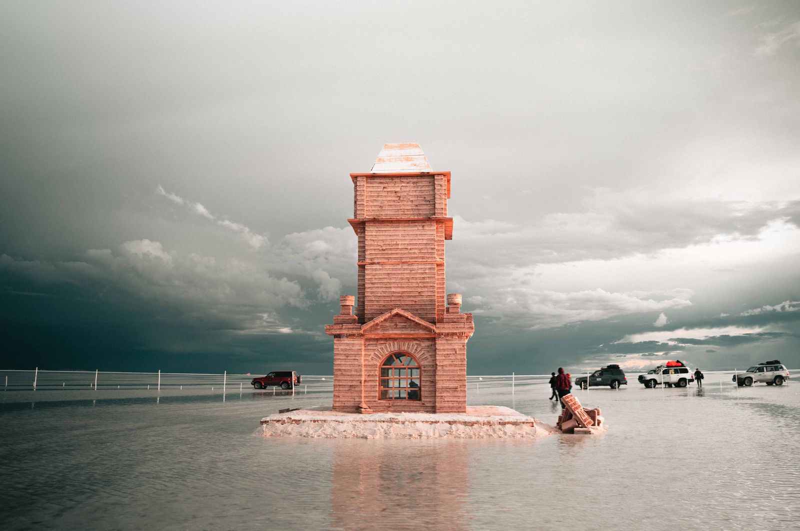
Day 4: Salar de Uyuni
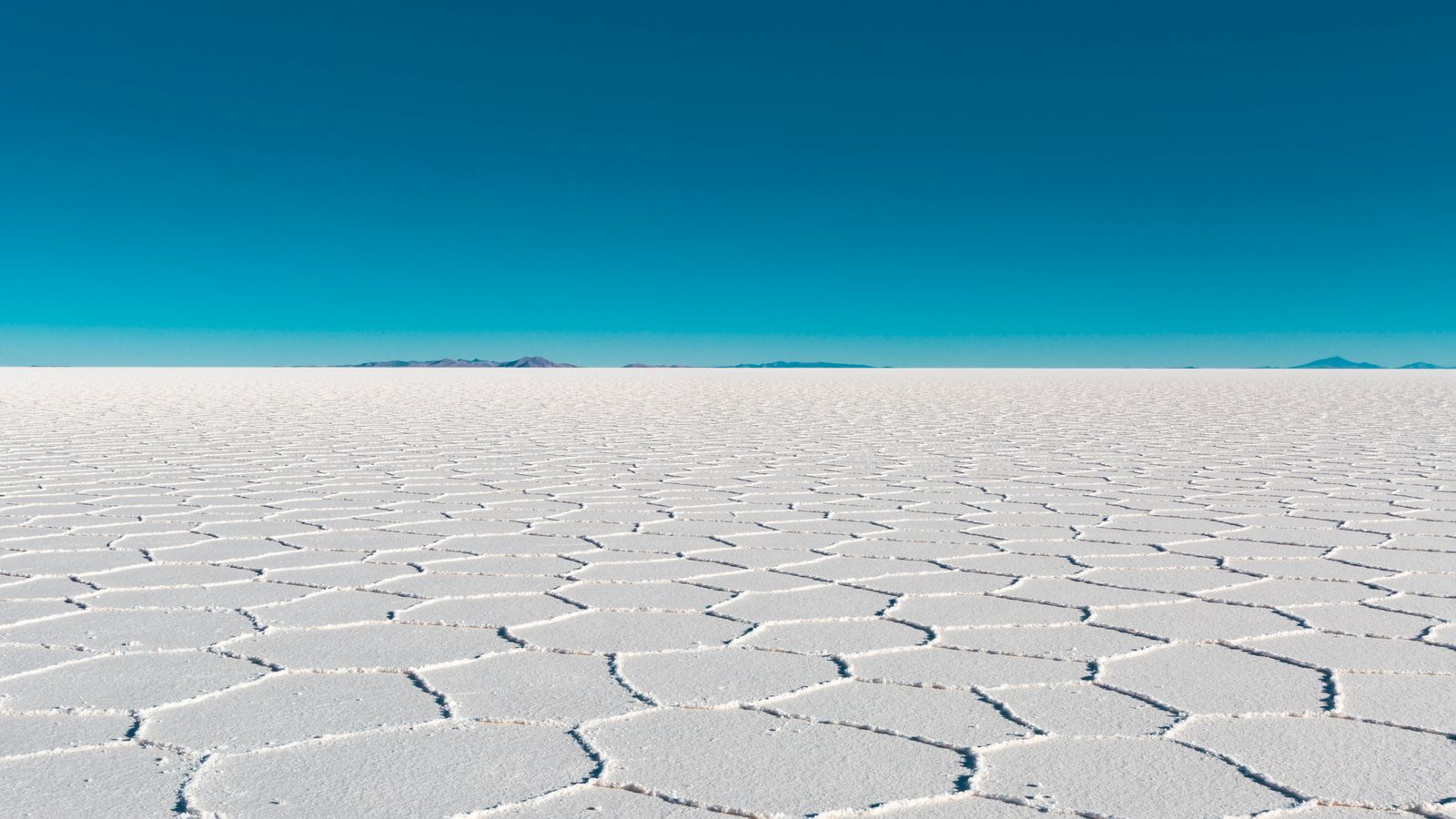
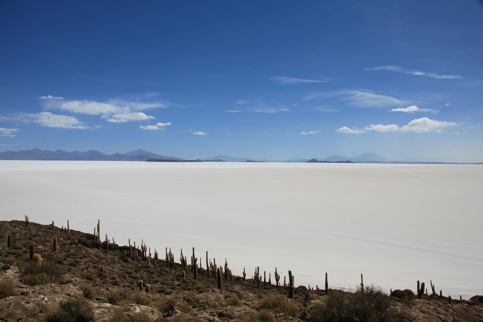
This is the day you came for. Start at Colchani on the salar's edge, then drive out across the open white to Incahuasi Island at about 3,656 m, a rocky outcrop studded with giant cactus that makes a natural lunch and viewpoint stop. Take the inevitable perspective photos on the flat, and if you can, stay for the sunset over the endless white expanse. One easily overlooked health point: UV exposure on the reflective salt is extreme, since the surface bounces sunlight straight back at you. Sunglasses, high-SPF sunscreen, and a brimmed hat are essential gear here, not extras, and snow-style glare can tire your eyes fast without them.
Want the health prep for Bolivia?
Get a 60-second pre-trip check: the vaccines, prescriptions, and altitude/seasonality notes that change the plan — built for your exact dates.
Day 5: South to the lagoons, Siloli Desert and Laguna Colorada
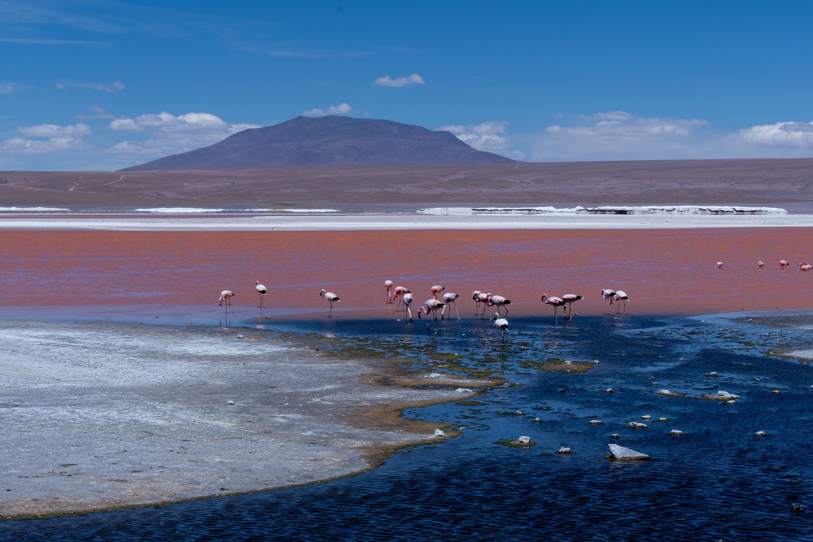
A long 4x4 day carries you across the altiplano past the Arbol de Piedra rock formations to Laguna Colorada, the red lagoon at about 4,278 m, often dotted with flamingos. You will sleep near the reserve tonight at your highest sleeping altitude of the trip. This is the night to pay attention: a headache that worsens, nausea, or breathlessness at rest are signals to flag, not tough out.
Day 6: Sol de Manana geysers and Laguna Verde
An early start, often before dawn, takes you to the Sol de Manana geothermal field at about 4,900 m, the peak altitude of the entire trip, where bubbling mud pools and steam vents sit in the cold thin air. From there you continue to Laguna Verde, the green lagoon beneath the cone of Licancabur volcano near the Chilean border, with a hot spring stop along the way. Keep the time at the geysers short and move calmly, since this is the thinnest air you will breathe all week. After the high point, the route turns and descends toward Uyuni, and for altitude, descending remains the single most reliable treatment there is.
Day 7: Uyuni back to La Paz, depart
Return to Uyuni and connect to La Paz for your onward flight. You finish the week lower than you slept midweek, which is a gentle way to end. If altitude symptoms lingered at all, consider a low-altitude buffer night before any long-haul flight home rather than going straight from the altiplano to the air.
Health prep for this trip
Altitude is the organizing health concern of this itinerary, so prep starts there. Four to six weeks out, see a provider to discuss acetazolamide, which is commonly used to help prevent altitude illness when started 1 to 2 days before ascent and continued during the climb. You can read more on the acetazolamide page and bundle it with the rest of the kit through the Bolivia salt flats travel-medicine bundle.
The second concern is the road. The southern lagoon circuit is long and rough, and motion sickness is real on those tracks. Some travelers carry an anti-nausea option such as ondansetron for the worst stretches; ask your provider whether it suits you. Confirm your routine vaccines are current. On this highland route, CDC generally does not recommend yellow fever vaccination for travel limited to areas above 2,300 m, and malaria risk sits below about 2,500 m, so the salar route falls outside both zones. Always verify current guidance for your exact plan.
What to pack
Pack for cold, sun, and thin air at once, because you will hit all three in a single day on the southern circuit. The essentials: layered clothing including a warm insulated jacket for sub-freezing nights near the reserve, thermal base layers, gloves, and a hat for the pre-dawn geyser start. For the sun, bring a brimmed hat, high-SPF sunscreen, lip balm with SPF, and quality sunglasses for the brutal salt-flat glare. Carry more water capacity than you think you need and a refill plan, since hydration is part of altitude management. Round it out with any altitude or anti-nausea medication discussed with your provider, a basic first-aid kit, a headlamp, a power bank because charging is unreliable, and cash in bolivianos, because card access is scarce once you leave Uyuni.
Best time to go and what to avoid
The salt flats have two faces, and neither is a health risk; the choice is about what you want to see.
Whatever the season, the altitude does not change. Avoid the common mistake of compressing the trip to skip the La Paz acclimatization nights, which is the single most reliable way to ruin the week.
Cost expectations
A 7-day trip of this shape typically combines a few nights of city and town lodging with a multi-day organized 4x4 tour of the salar and lagoons, which is where most of the budget goes. Costs swing widely with comfort level, group versus private vehicle, and season, and the cheapest tours often cut corners on exactly the things that matter at altitude. Treat the tour operator's safety record, driver experience, and vehicle condition as more important than price, because on the remote southern circuit you are hours from the nearest clinic and the ability to descend quickly is your main safety margin. It is reasonable to ask an operator directly how they handle a traveler who gets sick at the lagoons; a good one has a clear answer.
Day-by-day plan
| Day | What you're doing | Health note |
|---|---|---|
| 1 | Arrive in La Paz, rest at altitude Land at El Alto (about 4,061 m), transfer down into La Paz, and do almost nothing on purpose. | El Alto airport is higher than the city. Expect a headache. Hydrate, skip alcohol, and rest the first 24 hours. |
| 2 | La Paz acclimatization day Low-exertion sightseeing only: the Mi Teleferico cable cars, a slow walk through the markets, Valle de la Luna. | This is a built-in acclimatization night, not a buffer you can skip. Most altitude illness is preventable with time. |
| 3 | La Paz to Uyuni Short flight or an overnight bus to Uyuni town (about 3,669 m). Afternoon at the Train Cemetery. | You are not gaining much altitude today, which is the point. Keep fluids up before the salar tomorrow. |
| 4 | Salar de Uyuni: Colchani, salt flats, Incahuasi Island Cross the salt flat to Incahuasi Island (about 3,656 m), shoot the perspective photos, stay for sunset. | UV is extreme on the white salt. Sunglasses, SPF, and a brimmed hat are medical gear here, not accessories. |
| 5 | South to the lagoons: Siloli Desert and Laguna Colorada Long 4x4 day across the altiplano to Arbol de Piedra and Laguna Colorada (about 4,278 m). Overnight near the reserve. | Tonight is your highest sleeping altitude. Watch for worsening headache, nausea, or breathlessness at rest. |
| 6 | Sol de Manana geysers and Laguna Verde Pre-dawn run to the Sol de Manana geysers (about 4,900 m) and Laguna Verde, then descend toward Uyuni. | This is the peak altitude of the trip. Keep the visit short, then descending is the most reliable treatment. |
| 7 | Uyuni back to La Paz, depart Return to Uyuni and connect to La Paz for onward flights. You finish lower than you slept midweek. | If altitude symptoms lingered, build a low-altitude buffer night before a long-haul flight home. |
Frequently Asked Questions
Many travelers on this route consider it. The entire trip sits above 3,000 m and tops out near 4,900 m at the Sol de Manana geysers, and per CDC, 40 to 50 percent of unacclimatized people develop acute mountain sickness within 12 hours at sustained altitudes over 3,000 m. Acetazolamide is commonly used to help prevent altitude illness when started 1 to 2 days before ascent. Whether it is right for you depends on your history, so speak with a provider first.
La Paz sits at about 3,640 m (11,942 ft) and Salar de Uyuni at about 3,656 m (11,995 ft), per CDC and regional sources. The Eduardo Avaroa reserve climbs higher, with Laguna Colorada near 4,278 m and the Sol de Manana geysers near 4,900 m. Every night of this trip is spent above 3,000 m.
Because time at altitude is the most reliable way to prevent altitude illness. CDC advises against ascending from below 1,200 m to above 3,500 m in a single day, which is roughly what flying straight to the altiplano does. Two acclimatization nights let your body adjust before the higher lagoon days.
Generally no, on this highland route. CDC notes malaria risk in Bolivia is below about 2,500 m, concentrated in the northern Beni and Pando departments, and yellow fever vaccination is not recommended for travel limited to areas above 2,300 m. Salar de Uyuni at about 3,656 m sits above both risk zones. Confirm current guidance for your exact route with a provider.
The dry season, roughly May to October, gives clear skies, firm salt, and full access to spots like Incahuasi Island. The wet season, roughly December to March, produces the famous mirror effect when a thin layer of water covers the flat. Both are valid; the choice is photographic, not medical.
The southern altiplano days are long and rough over unpaved tracks, which can trigger nausea. Sitting in the front, looking at the horizon, and eating lightly all help. Some travelers carry an anti-nausea option such as ondansetron for the worst stretches. Ask a provider whether it fits your situation.
Yes. Many travelers run the loop in reverse from San Pedro de Atacama in Chile, finishing in Uyuni. The health logic is the same: the route still peaks near 4,900 m, so the acclimatization principle holds regardless of direction. This itinerary uses La Paz as the entry point.
Per CDC, seek care for severe headache, breathlessness that continues at rest, severe fatigue, loss of coordination, or confusion. These can signal more serious altitude illness. The most effective response is to descend. Most travelers should treat worsening symptoms as a reason to go down, not push on.
Stick to bottled or treated water and be cautious with food on the remote southern circuit, where facilities are basic. Traveler's diarrhea is less of a headline risk here than altitude, but it is worth a conversation with your provider about a plan, since being sick at 4,000 m is miserable.
Mark Karam, PA-C is a board-certified Physician Associate with emergency and urgent care experience and co-founder of Wandr Health.